Prospections and Settlement Archaeology in Westphalia
Contacs:
A landscape like Westphalia is shaped by its numerous natural conditions which affect the detection and the preservation of archaeological sites in various ways. For some time now the prehistoric archaeology engages in different survey methods like aerial archaeology and geomagnetic prospection. Consequently the Institute of Archaeological Studies (Prof. Dr. Th. Stöllner/W. Ebel-Zepezauer) in cooperation with the colleagues of the LWL Department of Archaeology (M.M. Rind) started to develop trendsetting concepts for Westphalia.
100 Years of Tradition
In Westphalia the survey of ground monuments has a tradition reaching back more than one hundred years yet a systematic and accurate aerial survey as well as the evaluation and georeferencing of the corresponding aerial images could not be realised. Previously there were no combined survey methods on archaeological sites and no flat information system which could manage the amount of georeferenced data. Furthermore the agricultural cultivation methods restrict active surveys to a few weeks per year and field-walking is usually not suited for documenting the extent of archaeological sites. Experience has shown that the extension of surface finds and the actual position and dimensions of ground monuments are rarely congruent. The intention of the ground monument conservation is to preserve and save the subterranean monuments of Westphalia from destruction. This can only be ensured when archaeological sites are systematically sought and as effectively as possible defined and preserved. This has been the starting point in 2010 of a project which aims to provide relief in future years.The Three Parts of the Project
The project consists of three parts: aerial archaeology, geophysics and geographic information system (GIS) (Fig. 01). The different survey methods are applied in combination with respect to the specifics of the archaeological site itself as well as the natural conditions of geology, hydrology and soil composition. The aim of this project is to research the context of soil development, soil erosion and accumulation, archaeological site structures with these different survey methods. Complementing this methodical approach, a further priority lies in the research of new settlement structures in selected geographic areas of Eastern Westphalia, in the region of Lippe and Ems, Hellweg and Siegerland during prehistoric times, early and late Roman Empire and the Middle Ages. The area under investigation covers the administrative districts Arnsberg, Detmold and Münster.
Fig. 01: The projects concept.
The Combination of Different Survey Methods
By combining the different survey methods, such as the airborne laser scan method (ALS), aerial archaeology, geomagnetic survey, ground-penetrating radar (GPR) and geoelectrics in various regions and soils, the validity of the combination method can be tested. Additional pedological examinations and radiocarbon dating help to comprehend the context of pedological conditions and the obtained data as well as the evaluation of future survey terrains. The entire data is managed and accessibly via a georeferenced system.
Fig. 02: Survey map of the archaeological sites and the used methods.
New Suspected Archaeological Sites
To date nearly 650 aerial images were taken (Dr. B. Song) which revealed about 90 partially new suspected archaeological sites and of which nearly 45 sites were able to be georeferenced and mapped (Fig. 02). Until 2012 fourteen sites were examined via geomagnetic prospection (B. Sikorski and students of the RUB) and three via ground-penetrating radar (Institute of Geophysics/RUB). Among those sites are the Carolingian rampart in Ahlen-Dolberg, the earthwork of the Michelsberger culture in Coesfeld-Harle, the deserted medieval town Corvey (Fig. 03), the Roman military encampment in Haltern am See, a possible motte in Hamm, a neolithic circular enclosure in Lünen, a Roman military encampment in Olfen, a neolithic earthwork in Soest-Müllingsen and many more.
Fig. 03: Grey scale image, area 12 – Weserknick (Corvey) with the detected anomalies.
Pedological Examinations
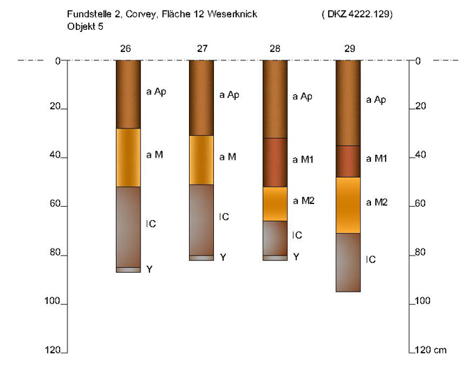
At five archaeological sites pedological examinations and datings (K. Röttger) could be performed which helped extend the archaeological interpretation of particular sites like Corvey (Fig. 04) and Olfen. The findings show clearly, that the use of combined methods provide significant results. Without ground intrusion it is possible to detect archaeological sites rapidly in their exact dimensions so they can be documented and protected.
Fig. 04: „Bohrkatene“ of a pedological examination in Corvey, area 12 – Weserknick, object 5.
