Aerial Archaeology in Westphalia
Ansprechpartner: Dr. Baoquan Song
Baoquan.Song@ruhr-uni-bochum.de
The Prehistoric Cultural Landscapes of Westphalia
Since 2010 and until 2013 the prehistoric cultural landscapes of Westphalia were tentatively surveyed as part of a collaboration between the LWL-Archäologie für Westfalen-Lippe and the Ruhr-Universität Bochum. During the research aerial archaeology, geophysical measurements, sharding and sondages were used. The purpose of this project was to find cost-efficient and effective methods for archaeological research by combining different modern field survey methods.Aerial Archaeology in Bochum
The institute houses a laboratory for aerial archaeology and conducts aerial surveys in China, Iran, Georgia and Spain and since 2002 in sporadically chosen areas of North Rhine-Westphalia as part of research project and the curriculum.As an effective, extensive and non-destructive method of prospection, the aerial archaeology is an important part of archaeology and the preservation of field monuments and as such have been an emphasis of the research and teaching of the Institute of archaeological science of the Ruhr-Universität Bochum for more than a decade. The Institute operates a laboratory for the evaluation of aerial archaeological photography and conducts courses and field surveys of archaeological airborne prospections, as well as campaigns in China, Iran, Georgia and Spain since 2002 also infrequently in chosen areas in North Rhine-Westphalia.
Westphalia from the Air
The aim of the following project is to examine how the cultural landscape of Westphalia with the aid of aerial archaeology can be investigated and if the methodology could be adjusted to local circumstances. With a modest budget of just 25 to 30 flying hours per year our work can only be an exemplary attempt. For a systematic flyover of Westphalia we would need approximately 150 to 200 flying hours yearly to cover this area. Nevertheless, in the last three years we were able to acquire essential methodical experiences in different cultural landscapes in our area of work and were able to discover more than 150 archaeological sites, which include earthworks, circular rampart complexes, settlements, military encampments, cemeteries, earthen boundary walls, roads and other traces of infrastructure, agriculture, castle ruins etc. which range chronologically from the prehistoric Neolithic to the Middle Ages.The Roman Garrison at Haltern
The Roman garrison at Haltern has been known to archaeologists for a long time and is mainly situated below the modern town. The only part that has not been overbuilt is the north-western corner of the garrison. Due to the aridity in the spring of 2011 the two trenches of the north-western fortifications of the garrison were visible for the first time on 15th May 2011. A little to the west were traces of an already researched temporal encampment and a newly discovered one. The traces of the garrison became clearer half a month later and the researchers were able to document the post holes of the wood-earth-wall via aerial photography. (Fig. 01). The earthen bridge of the ditch could be identified as the northern gate.
Fig. 01: The Roman garrison at Haltern.
The Motte “Schwatte Borg”
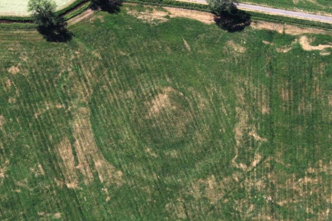
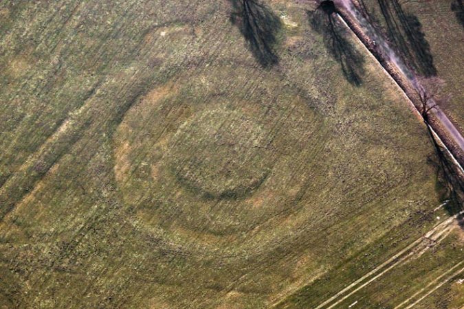
On behalf of the LWL- Archäologie für Westfalen the motte “Schwatte Borg”, which is located south of Dorsten-Rhade, was documented on 2nd June 2011. The complex seemed entirely levelled and was only visible as crop marks. Originally it was surrounded by three ditches which show traces of additional buildings visible as either positive or negative crop marks (Fig. 02). After a re-assessment flight on 10th February 2012 shadow marks were detected and revealed that the motte was still partially above ground visible as a ground relief with two ditches(Fig. 03).
Fig. 02: Positive and negative crop marks of the “Schwatte Borg”.

Fig. 03: Shadow marks of the “Schwatte Borg”.
The Medieval Motte-and-Bailey Castle “Fuchsspitze”
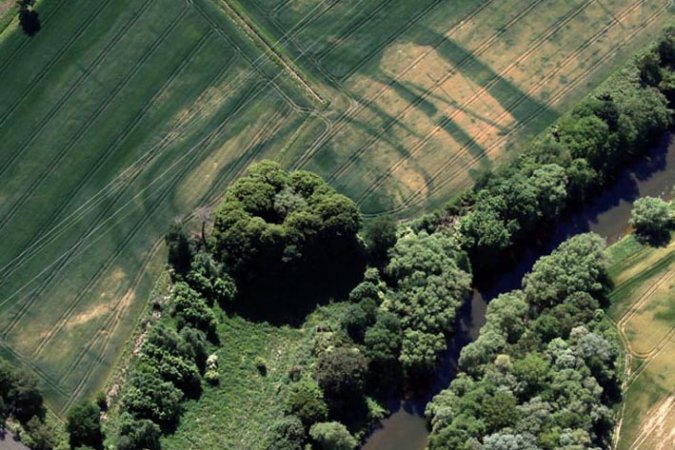
The medieval motte-and-bailey castle “Fuchsspitze” is situated on the southern bank of the river Lippe and the circular rampart “Burgstätte” just a little further up on the river terrace. They have been known to archaeologists for about 150 years. Initially it was assumed that the complex had its origin in Roman times until Prof. Albert Baum (1862-1934), director of the Dortmunder Kunst- und Gewerbemuseum, conducted excavations in 1897 and 1898. Spectacular aerial photographs, taken in 2011, shed new light on this important complex. Although the site has been regularly aerial surveyed since 2008 in connection with the exhibition “AufRuhr 1225” aerial photographs taken on the 25th May 2011 surprisingly revealed crop marks which indicate a levelled fortification complex with several ditches(Fig. 04).
Fig. 04: Crop marks of the levelled fortification.
